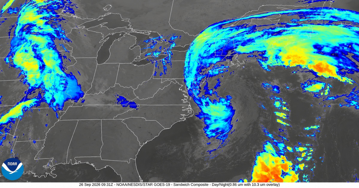
The nor’easter disrupting New York and New Jersey is no longer primarily a forecast story.
By Saturday morning, floodwater was covering streets in parts of coastal New Jersey and Long Island. Thousands of customers had lost power. Trees were down across Long Island. A fallen tree temporarily suspended part of the Long Island Rail Road’s Port Jefferson Branch. And communities that spent Friday preparing for high tides were beginning to see those warnings turn into actual flooding.
The storm had already reshaped the weekend before that happened.
New York and New Jersey declared emergencies across some of their most vulnerable counties. New York City issued a weekend travel advisory. Global Citizen, All Things Go and CBGB were canceled. Belmont Park abandoned its entire weekend racing schedule.
Now the central question has shifted.
It is no longer simply whether the nor’easter will produce serious impacts.
Those impacts have begun.
The question is how much worse coastal flooding becomes as the storm continues through additional high-tide cycles Saturday and Sunday.
Saturday morning brought flooding, fallen trees and outages
Long Island entered Saturday under heavy rain, strong winds and coastal-flood warnings.
By 8 a.m., Hempstead Town Supervisor John Ferretti said the town had recorded 19 downed trees overnight. Flooding was also reported in the Freeport and Island Park areas as heavy rain and strong wind affected western Nassau County.
Farther east, water was visible around a marina in Mastic Beach Saturday morning.
Power outages were also spreading.
At approximately 5:50 a.m., PSEG Long Island reported nearly 600 separate outages affecting more than 15,000 customers, according to News 12 Long Island.
Transportation was affected as well.
At about 8:30 a.m., Long Island Rail Road service on the Port Jefferson Branch was temporarily suspended between Huntington and Port Jefferson after a tree fell onto the tracks east of Kings Park. Trains were delayed while crews responded.
Additional road obstructions caused by downed trees or large branches were reported in communities including Uniondale, Wantagh, Brookville and Commack.
These are the kinds of effects that distinguish Saturday morning from Friday’s preparation phase.
The storm is now producing measurable consequences away from the immediate shoreline as well as along it.
New York’s forecast has become more serious
The latest National Weather Service forecast for the New York metropolitan area calls for a prolonged period of rain, strong winds and widespread coastal flooding through the weekend.
Across Long Island, storm-total rainfall is now expected to reach roughly 3 to 4 inches, with locally higher amounts possible.
Along exposed coastal areas, gusts of approximately 45 to 55 mph are expected, with isolated gusts around 60 mph possible.
But the greatest concern remains flooding.
The National Weather Service says widespread moderate to locally major coastal flooding remains possible across Long Island and Queens through Sunday morning, with the greatest major-flood risk focused on southern Nassau and southwestern Suffolk.
In those particularly vulnerable areas, coastal-flood warnings call for roughly 2½ to 3 feet of inundation above ground level, with locally higher water possible.
That is enough to close numerous roads, inundate low-lying properties and flood parked vehicles near bays, tidal waterways and the waterfront.
The danger is also not confined to one tide.
Persistent northeast winds can prevent water from fully draining out of bays before the next high tide arrives, allowing elevated water levels to linger or return.
New Jersey is already seeing serious coastal impacts
Along the Jersey Shore, the storm’s coastal component was already unmistakable Saturday morning.
CBS News and the Associated Press reported flooded roads in Manasquan, where officials had previously encouraged some residents in vulnerable areas to leave voluntarily.
In Ship Bottom, roads were submerged.
In Surf City, floodwater reached homes.
And in Ocean City, blocks of roadway were underwater as tidal flooding spread across low-lying portions of the barrier island.
Those observations matter because major coastal flooding was still primarily a forecast overnight.
By Saturday morning, some of the warned-about impacts were occurring.
The National Weather Service continues to forecast major coastal-flood levels along portions of the New Jersey Atlantic coast, although observed severity varies significantly by location.
Forecasts also call for breaking waves of roughly 6 to 12 feet and coastal wind gusts that could approach 60 mph.
The threat extends beyond oceanfront streets.
Back-bay communities can experience particularly serious flooding because water pushed through inlets becomes trapped behind barrier islands and may drain only slowly between tidal cycles.
That means a community can experience worsening flooding even when the rain itself is temporarily lighter.
The morning high tides answered part of the overnight question
The overnight forecast raised the question of whether Saturday morning’s high tides would produce the serious coastal impacts forecasters had warned about.
By mid-morning, part of that question had been answered.
Significant flooding was occurring.
Roads were underwater in multiple New Jersey communities.
Water had reached homes in Surf City.
Flooding was reported in Freeport and Island Park on Long Island.
Water was visible in Mastic Beach.
But that does not mean every forecast threshold was reached everywhere.
Coastal flooding varies dramatically depending on local elevation, exposure to bays or the ocean, tide timing and wind direction.
Some communities are dealing primarily with rainfall, fallen trees and power outages.
Others are experiencing much more substantial tidal flooding.
And the National Weather Service continues to warn that another significant coastal-flood cycle is possible Sunday morning, especially around Long Island and Queens.
The storm therefore cannot yet be described as having peaked across the entire region.
Why this is not simply a heavy-rain event
Rain is an important part of the storm.
But it is not the entire explanation for what is happening along the coast.
A slow-moving nor’easter produces prolonged northeast winds.
Those winds push ocean water toward New York and New Jersey and force it into bays, rivers and tidal waterways.
When wind-driven water coincides with astronomical high tide, the resulting water level can rise well beyond what either factor would produce independently.
And because this storm is moving slowly, several consecutive high tides can be affected.
That creates a different kind of flood problem from a short burst of heavy rain.
A low-lying road can flood during one high tide, partially drain and then flood again several hours later.
Water pushed into Jamaica Bay, Great South Bay or New Jersey’s back bays can remain elevated even after rainfall temporarily weakens.
Rainfall then compounds the problem because storm drains and waterways have fewer places to send runoff when coastal water levels are already high.
New York and New Jersey have declared emergencies
New Jersey Gov. Mikie Sherrill declared a state of emergency across eight counties beginning Friday evening.
The declaration covers Atlantic, Burlington, Cape May, Cumberland, Middlesex, Monmouth, Ocean and Salem counties.
The state said it was preparing for coastal flooding, heavy rain, damaging winds and beach erosion while coordinating resources among state and local agencies.
New York Gov. Kathy Hochul separately declared a state of emergency covering New York City, Long Island and Westchester County.
The declaration applies to the Bronx, Brooklyn, Manhattan, Queens, Staten Island, Nassau, Suffolk and Westchester, as well as contiguous counties covered by the executive order.
New York activated its State Emergency Operations Center and positioned utility crews, swift-water rescue teams and other resources to respond to flooding, outages and local requests for assistance.
The Town of Southampton added another emergency declaration Saturday morning, effective at 6 a.m., as eastern Long Island prepared for flooding, beach erosion, heavy rainfall and strong winds.
New York City also issued its own travel advisory covering Friday afternoon through Sunday morning.
These are different government actions.
The state declarations provide emergency authority and resources to government agencies.
The city advisory is public guidance focused on travel, flooding, weather hazards and preparedness.
Major events were canceled before the worst conditions arrived
The scale of the disruption was already evident before Saturday morning’s flooding.
The Global Citizen Festival, scheduled for Saturday on Central Park’s Great Lawn, was canceled after organizers consulted with New York City and NYC Parks.
Global Citizen said the expected conditions made it unsafe to bring tens of thousands of attendees, performers, workers, vendors and equipment into the park.
It was the first weather cancellation in the festival’s 14-year history.
The planned lineup included Ms. Lauryn Hill and Wyclef Jean, Lenny Kravitz, John Legend, Lainey Wilson, Shaboozey and TOMORROW X TOGETHER.
Two other major New York music festivals were also canceled:
- All Things Go NYC — all three Forest Hills Stadium dates were canceled.
- CBGB Festival — Saturday’s Brooklyn event was canceled because of severe weather and high winds.
Belmont Park also canceled its entire Saturday and Sunday racing schedule because of the nor’easter.
The disruption extends beyond those marquee events.
Other changes include:
- Atlantic Antic in Brooklyn — postponed.
- Yes Chef Food Festival at Citi Field — postponed.
- Broadway Flea Market and Grand Auction — moved indoors.
- IRONMAN 70.3 New York at Jones Beach — canceled because organizers said conditions could not meet required safety standards.
- Long Island Fair at Old Bethpage — Saturday canceled, with later scheduling dependent on conditions.
- Monsters on the Beach in Wildwood — postponed.
- Seafarers Celebration in Wildwood Crest — canceled.
- Shamrocks by the Sea in Seaside Park — canceled.
- River City Fair in Hoboken — postponed.
- Treasure Island Triathlon in Point Pleasant — postponed.
Fire Island ferry service was also heavily reduced, with Saturday passenger and freight service canceled on affected routes.
Those decisions increasingly look less like preparation for a theoretical threat and more like responses to conditions that were materializing Saturday morning.
The storm is now affecting infrastructure, not just weekend plans
The cancellations were an early measure of the storm’s reach.
By Saturday morning, the more consequential effects were increasingly about infrastructure and public safety.
Trees were blocking roads.
Thousands of Long Island customers had lost power.
A fallen tree had temporarily interrupted LIRR service.
Floodwater was reaching homes along the Jersey Shore.
Coastal roads were becoming impassable.
And another significant high-tide cycle remained ahead.
More than 70,000 customers across the East Coast were without electricity as of Saturday morning, according to CBS News and the Associated Press.
New York and New Jersey accounted for only part of that total, but the broader figure illustrates the scale of the wind impacts associated with the storm.
Strong winds remain especially problematic in September because many trees still have full foliage, allowing their canopies to catch more wind and increasing stress on limbs and root systems.
When soils are also saturated by rain, the risk of trees coming down can increase further.
What remains ahead Saturday and Sunday
The forward-looking question is narrower now than it was overnight.
Saturday morning has already demonstrated that this storm can flood roads and homes, knock down trees, interrupt power and disrupt transportation.
The concern for the rest of the weekend is whether those impacts deepen.
Across Long Island and Queens, the National Weather Service says widespread moderate to locally major coastal flooding remains possible through Sunday morning, with southern Nassau and southwestern Suffolk facing the greatest major-flood risk.
Persistent northeast winds will continue making it difficult for water to fully drain from bays between tidal cycles.
Additional rainfall can worsen street and drainage flooding.
Strong gusts remain capable of bringing down additional trees and power lines.
And New Jersey remains under a prolonged coastal threat.
Even where Saturday morning’s water begins to recede, later tides can push water back across roads and into vulnerable neighborhoods.
The storm’s disruption is no longer hypothetical.
Roads have flooded. Homes have taken on water in parts of New Jersey. More than 15,000 Long Island customers were affected by outages early Saturday morning. Trees are down. Rail service has been disrupted. Both states have declared emergencies. Three major music festivals are canceled, and Belmont Park has abandoned an entire racing weekend.
What remains uncertain is not whether the nor’easter will matter.
It already does.
The question now is how much additional flooding, wind damage and disruption the next 24 hours produce before the storm finally begins to release its grip on New York and New Jersey.
Sources
- NOAA/NESDIS/STAR — GOES-19 satellite imagery
Official source for the September 26 satellite composite used as this article’s hero and social-preview image. - National Weather Service — New York/Upton Area Forecast Discussion
Official forecast discussion describing storm-total rainfall, strong coastal winds and widespread moderate to locally major coastal flooding through Sunday morning. - National Weather Service — New York Coastal Flood Warnings
Official warnings covering southern Nassau, southwestern Suffolk and other vulnerable New York coastal areas. - National Weather Service — Mount Holly, New Jersey Area Forecast Discussion
Official forecast describing major coastal-flood potential along portions of the New Jersey Atlantic coast, multiple tidal-flood cycles, coastal gusts and dangerous surf. - National Weather Service — New Jersey Coastal Flood and High Surf Warnings
Official warning products detailing coastal inundation, roadway flooding, dangerous surf and tide forecasts along the New Jersey coast. - News 12 Long Island — Live nor’easter updates, September 26, 2026
Reporting on flooding, downed trees, outages, Southampton’s emergency declaration, road disruptions, the Port Jefferson Branch suspension, the Jones Beach IRONMAN cancellation and ferry disruptions. - CBS News / Associated Press — Nor’easter brings powerful winds and severe flooding to the East Coast
Reporting on flooding in Manasquan, Ship Bottom, Surf City and Ocean City, water entering homes, evacuation preparations and widespread East Coast power outages. - New Jersey Governor’s Office — State of Emergency, September 25, 2026
Official declaration covering Atlantic, Burlington, Cape May, Cumberland, Middlesex, Monmouth, Ocean and Salem counties. - New York State — Executive Order No. 63, September 25, 2026
Official state information covering New York City, Long Island and Westchester County during the coastal storm. - New York City Mayor’s Office / NYC Emergency Management — Nor’easter Travel Advisory
Official guidance covering expected rainfall, strong winds, coastal flooding and travel precautions. - Global Citizen — 2026 Festival cancellation and lineup
Official event page confirming the cancellation and identifying the planned Central Park performers. - AXS — All Things Go New York cancellation status
Official ticketing series showing all three Forest Hills Stadium dates—September 25, 26 and 27—as canceled. - CBGB Festival — Official cancellation notice
Official notice canceling the September 26 Brooklyn festival because of severe weather and high winds. - New York Racing Association — Belmont Park weekend cancellation
Official announcement canceling Saturday and Sunday racing because of the nor’easter. - amNewYork — Nor’easter disrupts weekend events across New York City
Reporting on postponed, canceled and relocated street fairs, food festivals and community events.
This article was prepared with AI assistance and reviewed and approved by TrendPulse Analytics before publication.